Rock Creek and Eastern Tributary Subbasins
Fish Habitat | Hydro| Hatchery | Limiting Factors | Management Strategies & Actions | Publications | MAP
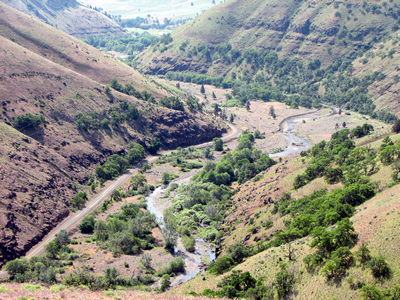 Rock
Creek Subbasin, located in Water Resource Inventory Area 31 (Rock-Glade
WRIA 31) within Klickitat County in southeastern Washington, is home to
a population of native steelhead. Rock Creek joins the Columbia River
at RM 230, about 12 miles upstream of John Day Dam. Lake Umatilla, the
reservoir behind the dam, inundates the lower mile of Rock Creek. As of
the 2000 census, the subbasin's population was 503. The current range
of steelhead in the Rock Creek watershed is believed to generally resemble
the historical condition, although some stream sections that probably
once supported spawning and rearing may now serve only as migration corridors
due to habitat degradation. The population of summer steelhead is part
of the Cascade Eastern Slope Tributaries MPG. Based on preliminary indications,
the YN believes that there may be a winter steelhead run also, and proposes
additional data collection to determine whether there is a split between
the runs. The population is sustained through natural reproduction. Less
than a handful of out-of-subbasin fin-clipped fish have been observed
over several years of observation.
Rock
Creek Subbasin, located in Water Resource Inventory Area 31 (Rock-Glade
WRIA 31) within Klickitat County in southeastern Washington, is home to
a population of native steelhead. Rock Creek joins the Columbia River
at RM 230, about 12 miles upstream of John Day Dam. Lake Umatilla, the
reservoir behind the dam, inundates the lower mile of Rock Creek. As of
the 2000 census, the subbasin's population was 503. The current range
of steelhead in the Rock Creek watershed is believed to generally resemble
the historical condition, although some stream sections that probably
once supported spawning and rearing may now serve only as migration corridors
due to habitat degradation. The population of summer steelhead is part
of the Cascade Eastern Slope Tributaries MPG. Based on preliminary indications,
the YN believes that there may be a winter steelhead run also, and proposes
additional data collection to determine whether there is a split between
the runs. The population is sustained through natural reproduction. Less
than a handful of out-of-subbasin fin-clipped fish have been observed
over several years of observation.
Rock Creek shares Rock-Glade WRIA 31 with other tributaries to the Columbia River (moving east): Chapman Creek, Wood Gulch Creek, Pine Creek, Alder Creek, Dead Canyon Creek, and Glade Creek. There is a paucity of data regarding fish distribution, species composition, etc. for fish populations in these watersheds, however, it is known that most are populated by resident fish, and some of them by anadromous fish, in some cases by ESA-listed steelhead of the Middle Columbia DPS.
Primary Limiting Factors and Threats --Rock Creek Steelhead
The primary factors and threats limiting steelhead populations in Rock Creek were identified based on results from EDT analysis. While some of these limiting factors--such as low summer flows and high summer water temperatures--likely occur naturally in some parts of the watershed because of bedrock terrain and steep slopes, anthropogenic changes in the subbasin have likely increased the intensity of such factors.
- lack of key habitat quantity and habitat diversity
- loss of riparian vegetation and function
- increased hydroconfinement
- altered hydrology with low summer flows
- high water temperatures
- increased fine sediment delivery
- altered food web
- predation and competition with exotic species
- mainstem Columbia River passage
- Lake Umatilla, the reservoir behind the John Day Dam, inundates the lower mile of Rock Creek and results in loss of critical wetland and riparian habitat
- Increased predation and competition with exotic species in lower Rock Creek.
- Hatchery strays of upriver origin may enter and spawn in Rock Creek, but their effect is unknown.
Top Priority Management Strategies and Actions
The limiting factors
and threats analysis was used to identify tributary habitat recovery strategies
and actions. They are consistent with actions identified in the Lower
Mid-Columbia Mainstem Subbasin (including Rock Creek) Management Plan
(NPCC 2004), and address risks identified in the ICTRT's viability assessment
for the population. The strategies and actions build from past and current
efforts to improve habitat conditions in the subbasin.
Key strategies and actions to address freshwater habitat limiting factors
include:
- Protect and
conserve natural ecological processes that support the viability of
populations and their primary life history strategies throughout their
life cycle.
- Key actions: apply BMPs to forest, grazing, agricultural and road construction practices; conservation easements and cooperative agreements
- Priority locations: entire watershed
- Gain information
needed to identify habitat strategies and actions that will provide
the greatest opportunity to contribute to steelhead recovery.
- Key actions: Gather information to complete gap analysis, evaluate steelhead distribution in subbasin.
- Priority locations: none identified
- Restore passage
and connectivity between habitat areas.
- Key actions: remove dikes, replace culverts and other artificial structures that obstruct fish passage, monitor effectiveness of passage improvements.
- Priority locations: Rock Creek between Old Highway 8 bridge and Badger Gulch
- Restore floodplain
function and channel migration processes.
- Key actions: restore natural channel form, reconnect side channels, introduce large woody debris, relocate or improve floodplain infrastructure and roads.
- Priority locations: Rock Cr below unnamed trib at RM 19.2, Squaw Cr. watershed, Luna Gulch, upper watershed tributaries; Rock Creek between Old Highway 8 bridge and Badger Gulch
- Restore riparian
function and condition.
- Key actions: restore riparian cover with conifers and other native vegetation
- Priority locations: Rock Cr. below unnamed trib. at RM 19.2, Luna Gulch, lower Squaw Cr.
- Restore altered
hydrograph to provide needed flows during critical periods.
- Key actions: protect/rehabilitate springs
- Priority locations: upper watershed
- Restore degraded
water quality, including water temperatures.
- Key actions: construct water and sediment control basin
- Priority locations: upper watershed
Fish and Habitat Assessment in Rock Creek, Klickitat County, Washington, 2016−17 Open-File Report 2019-1092 (Hardiman and Harvey, 2019)
Fluvial Reconnaissance of Rock Creek and Selected Tributaries with Implications for Anadromous Salmonid Habitat Management Rock Creek, Klickitat County, WA (Conley, 2015) Report and Appendices
Rock Creek Fish and Habitat Assessment for Prioritization of Restoration and Protection Actions -- June 1, 2008 – May 31, 2013 (Yakama Nation Fisheries Resource Management, 2013)
Recovery Plan for the Rock Creek Population of the Middle Columbia River Steelhead Distinct Population Segment (National Marine Fisheries Service, 2009)
Lower Mid-Columbia Mainstem Subbasin Plan (Northwest Power and Conservation Council, 2004)
Washington State Dept. of Ecology stream flow monitoring station Rock Cr. @ Old Hwy 8 Bridge