Major
Creek Subbasin
 Major
Creek is a Water
Resource Inventory Area (WRIA) 30 tributary which drains directly into the
Columbia just to the west of the Klickitat subbasin. The Major Creek watershed
covers about 28 sq. miles. The East and West forks of Major Creek converge,
flowing 4.1 miles downstream to the Columbia River, dropping 620' in elevation.
The West Fork originates at two catch basins at 2100', flowing 5 miles through
a narrow box canyon, then valley to the confluence with the East Fork, losing
1360' in elevation. The East Fork flows from a drainage basin 5.1 miles through
a narrow, v-shaped valley, losing 1490' in elevation, to join the West Fork.
Major
Creek is a Water
Resource Inventory Area (WRIA) 30 tributary which drains directly into the
Columbia just to the west of the Klickitat subbasin. The Major Creek watershed
covers about 28 sq. miles. The East and West forks of Major Creek converge,
flowing 4.1 miles downstream to the Columbia River, dropping 620' in elevation.
The West Fork originates at two catch basins at 2100', flowing 5 miles through
a narrow box canyon, then valley to the confluence with the East Fork, losing
1360' in elevation. The East Fork flows from a drainage basin 5.1 miles through
a narrow, v-shaped valley, losing 1490' in elevation, to join the West Fork.
The Major Creek Planning
Area covers 7,200 acres of land, under a mix of ownership including U.S.
Forest Service, BIA
trust lands, Washington Department
of Natural Resources, and private landowners. According to official journals,
the Lewis and Clark expedition camped at the mouth of Major Creek on April 14,
1806, just below a Native American village.
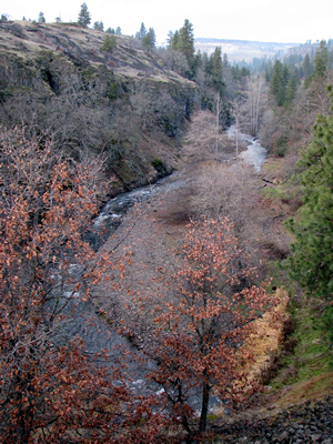
Major Creek has a relatively
straight, high energy, swiftly dropping channel incised into the Columbia River
basalt layers. Streamside vegetation is relatively dense, and the rate of downcutting
generally does not seem to be outstripping the rate at which the riparian vegetation
can stabilize the stream banks. Water quality appears to be high. The Major
Creek landscape is canyon-dominated with very little road contact, and except
for the uppermost portion of the watershed, the watershed is very lightly managed.
The vegetation is dominated by grasslands and oak woodlands in the lower sections,
while the higher elevations are more forested, with Douglas and grand fir, and
some intermittent oak woodlands and hay lands. The riparian areas along the
lower stretches of Major Creek have a good diversity of oak, ash, alder, willow
and big leaf maple. Despite impact from human activities, most of the ecological
functions are intact (USFS 1994).
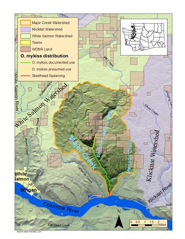
Fisheries
Middle Columbia River ESA-listed steelhead (Oncorhynchus mykiss), fall
Chinook (O. tshawytscha) and coho salmon (O. kisutch) spawning
activity has been documented in the lower 1/3 mile of Major Creek. Adult steelhead,
some with adipose fins, have been observed in this same section in spring staging
below each of the lower falls and attempting to jump the third step falls. O.
mykiss are present up to a 30-foot barrier waterfall at RM 1.4 on the West
Fork and to the natural barrier at RM 1.2 on the East Fork of Major Creek, though
precise extent of distribution remains to be determined.
YKFP staff
have conducted limited surveys in this watershed; further data about numbers,
species composition, distribution, genetic origin and other life history information
is considered a research need.
|
|
 to
Yakama Nation Southern Ceded Lands to
Yakama Nation Southern Ceded Lands |