
Logs and log jams were historically common
blocked navigation
even in some of the largest rivers in the country.
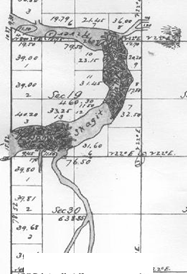
•Two large
jams on the Skagit River appear on the GLO plat maps in 1873
•One jam
(~1/2 mile downstream of Mt. Vernon) had been in place sufficient to block river traffic for nearly 100 years
•A second
jam (roughly one mile upstream of Mount Vernon) was younger, but was “rapidly increasing in size at the rate of
a quarter
mile every three years.”
•The only
way around the jam was “A rude skid road built by Upper Skagit Indians to haul their canoes…”
•In the
summer of 1876, removal began using crosscuts saws and axes
•Removal
involved cutting “through five to eight tiers of logs three to eight feet in diameter, totaling 30 feet deep”
•Removal was completed in 1879.
http://crowleyassoc.com/essays/output.cfm?file_id=5652
Skagit River logjams, 1873
Courtesy U.S. Bureau of Land Management