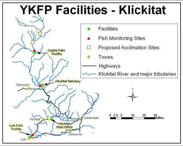
Click
on one of the links above or on
one of the green symbols on the map below to go to information about that
particular facility.
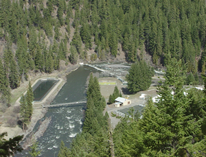
Originally constructed between 1950 and 1954, the Klickitat Hatchery was funded under the federal Mitchell Act of 1938 as mitigation for effects of hydropower development and operation. It is the centerpiece of artificial propagation activities in the Klickitat subbasin, and is used at least in part to rear and release spring and fall Chinook and coho salmon. In addition, steelhead smolts are released annually directly into the lower Klickitat at several locations downstream of the Klickitat Hatchery. On June 2, 2003, a Memorandum of Understanding (MOU) was completed that describes the operational responsibility of the Klickitat Hatchery and the Lyle Falls and Castile Falls fishways between the WDFW and the Confederated Tribes and Bands of the Yakama Nation (YN). In May of 2006, the Yakama Nation officially assumed responsibility for the operation of the Klickitat Hatchery.
Proposed changes to the Spring Chinook artificial production program that meet Hatchery Scientific Review Group reform criteria can be found in the Klickitat River Spring Chinook Anadromous Fishery Master Plan (link to 2018 draft, below). This draft master plan is currently in Step II of the NPCC 3-Step review process for major artificial production initiatives.
Draft EIS - Klickitat Hatchery Upgrades to Support Spring Chinook Program
Klickitat River Spring Chinook Anadromous Fishery Master Plan (January 2018)
Appendix A Spring Chinook Hatchery Genetic Management Plan (HGMP) (February 2019)Appendix B Klickitat spring Chinook: Integrated program description, analysis, and implementation schedule (February 2019)
Fall Chinook HGMP (final Nov. 2013)
Coho HGMP (final Nov. 2013)
YKFP Co-manager response to Federation of Fly Fishers' May 2011 article in "The Osprey" newsletter (August 16, 2011)
 Klickitat
Hatchery
Klickitat
Hatchery![]()
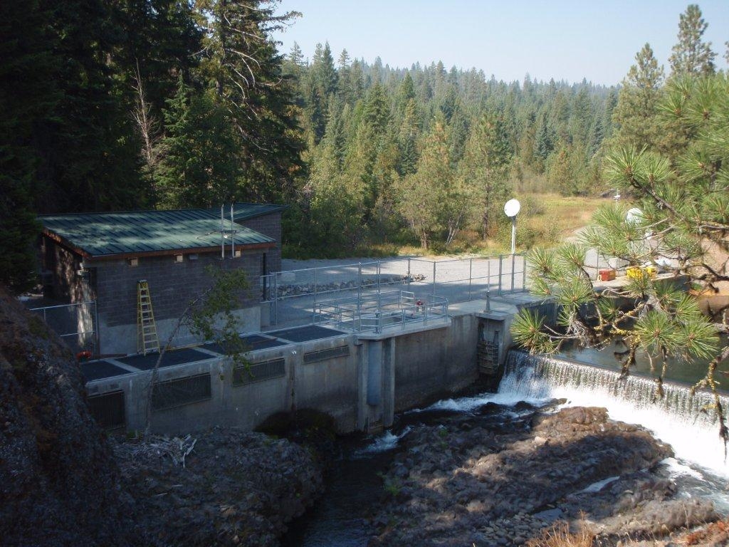
Castile Falls, a severe natural obstruction in the upper Klickitat River gorge (RM 64) consisting of multiple cascades and waterfalls, was an historic impediment to the upstream migration of the majority of anadromous fish into the upper Klickitat watershed. Castile Falls is a series of eleven natural falls with a vertical drop of 108 feet over 0.67 miles.
Fishway development
Fishways were constructed by Washington Dept. of Fisheries (WDF) in the early 1960s with Mitchell Act funds to provide anadromous access to approximately 33 miles of spring Chinook and 55 miles of steelhead habitat above the falls. Limitations in design understanding at the time and infrequent maintenance contributed to the failure of the first attempt to provide passage over the falls. A plan view drawing depicts the entire series of falls with fishways that were constructed (from 1960s), and an original 3D design drawing from the late ’50s-’60s shows the attempt to tunnel through 3000’ of rock for fish passage facilities. Due to poor geotechnical material encountered early in the tunneling, WDF was then forced to construct three different fishways, located between river miles 64.0 and 64.7. Falls Numbers 2, 3, and 6 were not considered fish barriers, so no "corrective blasting" was undertaken. The remaining falls, Numbers 1, 4, 5, 7, 8, 9, 10, and 11, were all altered.
RenovationsRecently, the Castile Falls Fishway was renovated to bring it into compliance with NOAA Fisheries' fish passage standards and facilitate anadromous fish passage to habitats in the upper subbasin. From 2003-2005, work was completed on the two fishway tunnels within the Castile Falls complex. Improvements were approved by NOAA Fisheries in 1999 under special appropriations to the Mitchell Act to perform major maintenance activities after the severe 1996 flood, which caused damage to several fishways in the Pacific Northwest. Construction activities were completed in summer 2005 opening access, blocked for over 40 years, to over 50 miles of habitat in the upper Klickitat to salmon and steelhead.
Design improvements consist of conversion from a pool-weir-style fishway to a vertical slot fishway to allow passage over a wider range of river flow conditions and to reduce maintenance needs. Project engineers and biologists have measured improved flow, attraction flow and energy dissipation factor (EDF) within the weir--all of which meet current criteria for fish passage.
Through BPA Columbia Basin Fish Accords funding, a monitoring facility was constructed at the terminus of the uppermost fishway tunnel. This facility, completed in summer 2012, now provides fisheries managers the ability to accurately monitor passage into the upper basin. A series of Passive Integrated Transponder (PIT) antennas records previously PIT-tagged fish, and an in-fishway digital video fish-detection array provides critical biological data such as species, run timing, size, and sex ratio of returning naturally produced adult spring Chinook and steelhead into the upper Klickitat basin. A 2500-gallon, double-walled diesel tank with a capture-flow system to prevent spills provides remote power generation. Two alternating diesel generators supply power to the digital image capture and PIT-tag detection systems. The motion of fish passing the camera triggers 5 seconds of digital video capture before and after the detection, and those frames captured are transferred from a digital video recorder via satellite to Toppenish for review and analysis. The facility receives year-round O&M visits, and alarm sensors send information about any operational malfunction or emergency to staff cell phones for rapid response.
View construction photos from the Castile Falls fishway improvements 2010-2011 (requires Adobe Flash 7 player).
Castile Falls Adult Enumeration Facility (CFEF)
The Castile Falls Enumeration Facility (CFEF) provides the ability to enumerate escapement into the upper Klickitat subbasin, and assess recent improvements to the Castile Falls Fishway. A counting station installed at the fishway exit of the Castile Falls 10/11 Fishway tunnel includes video monitoring and PIT-tag detection capabilities, as well as the ability to trap salmon and steelhead for biological and DNA assessment and brood stock collection. The enumeration facility allows fisheries managers to:
- determine escapement of Klickitat spring Chinook, summer steelhead and Pacific lamprey into headwater habitats
- assess stock status and future trends as needed to calculate natural production and adult-to-adult return rates, and to refine EDT and run forecasting models used to guide integrated and conservation hatchery programs and set harvest objectives
- conduct video monitoring to gain critical biological data such as species, run timing, size, and sex ratio of returning adults; and
- collect age and DNA information on returning adults.
- assist with effectiveness monitoring of habitat restoration projects.
Castile Falls Fishway #4/5 Drawings
Castile Falls Fishway #10/11 Fishway Drawings
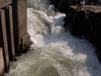
Lyle Falls Fishway and Adult Trap
Lyle Falls is really a series of five falls located on the Klickitat River above the confluence with the Columbia River between river mile (RM) 2.0 and 2.2. The uppermost falls, Klickitat Falls No. 5, is approximately 150 feet in length and is bypassed by the Lyle Falls fishway located on the west bank. Data on adult fish using the fish ladder are collected daily.
Fishway development
The Washington State Department of Fisheries (WDF) began building the original reinforced concrete fishway at Lyle Falls in 1949. By 1955, more formal facilities were constructed (photo). The facility was a vertical slot weir covered fishway, with a three-port entrance pool, trapping and sorting bays. A siphon was retrofitted above the fishway to provide attraction water in the 1960's. Fish passage at Lyle Falls No. 5 met with some success over the years, but did not fully function as intended. Bedload and debris accumulations continually entrained material into the fishway, minimizing exit pool depths and increasing operation and maintenance. The siphon auxiliary water system designed to increase attraction flows at the fishway entrance would often not hold a charge due to bedload accumulation, nor was it properly screened and configured to eliminate impingement and entrainment of juvenile fish.
Fishway issues and resolution
Under the above conditions, passage through the Lyle Falls fishway could become difficult during low flow conditions. At low flows, minimal water passed through the fishway, whose exit channel was often shallow with exposed bedload, resulting in fish reluctant to enter and exit the fishway. New fish passage technology, improved since original construction, provided solutions to remedy problems with the fishway and facilitate increased passage through a wider range of flows, particularly during low flow conditions.
Engineering assessments (Harbor Consulting Engineers, Inc. 1996) identified the following factors restricting passage at the fishway:
Inadequate attraction water Location of the fishway entrance
Configuration of the fishway entrance ports
Location of the fishway exit, with fish exiting into swift water
Trash rack debris accumulations
River shoaling at the fishway exit
Hydraulic analysis coupled with fisheries passage information developed by NOAA and WDFW was used to identify needed repairs, modifications, and retrofits that would facilitate increased passage into the Klickitat River basin. Engineering and design work for Lyle Falls provided for a facility that allows a high proportion of returning fish to be physically examined at a location in the lower watershed.
Improvements were undertaken at Lyle Falls Fishway to address limited adult fish passage through the fishway into the Klickitat subbasin. Bonneville Power Administration (BPA)
finalized the Environmental Impact Statement for the Lyle Falls Fish Passage Project which contained a Record of Decision recommending moving forward with construction, as well as a detailed plan to mitigate for construction impacts, including native revegetation of the project site. The recommended action consisted of modifying the existing fishway to safely and more effectively allow adult fish to move through the existing Lyle Falls into spawning areas in the upstream reaches of the Klickitat River.
Improvements would also include reconstructing and lengthening the fishway and trash racks; upgrading the adult trapping facility and adding a Passive Integrated Transponder (PIT)-tag detector would facilitate collection of fish for broodstock purposes and monitoring of biological information for future fishery management. The PIT-tag detection system enables escapement monitoring, provides run-timing information, improves enumeration of natural- and hatchery-origin recruits returning to the subbasin, and may also assist in determining the presence/absence of a fluvial bull trout population. An "eelway", a specially designed lamprey passage device, was also added. For more details about and photos of the construction on the Lyle Falls fishway and adult fish trap initiated in spring 2010, click here. At the peak of construction, this project provided 90 jobs.
Lyle Falls Fishway is a busy working facility. If you are interested in scheduling a tour, please contact us.
Lyle Falls Fish Passage Project Record of Decision with Mitigation Action Plan
Lyle Falls Fish Passage Project Final EIS (November 2008)
KLICKITAT RIVER PROPOSED FISHWAY IMPROVEMENTS at Lyle Falls Hydraulic Conditions Report (January 2004)
Lyle Falls No. 5 Fishway Drawings
Preliminary Design Report for Klickitat River Fish Passage Improvements Technical Report 2001-2005 (YKFP and Harbor Engineering June 2006)
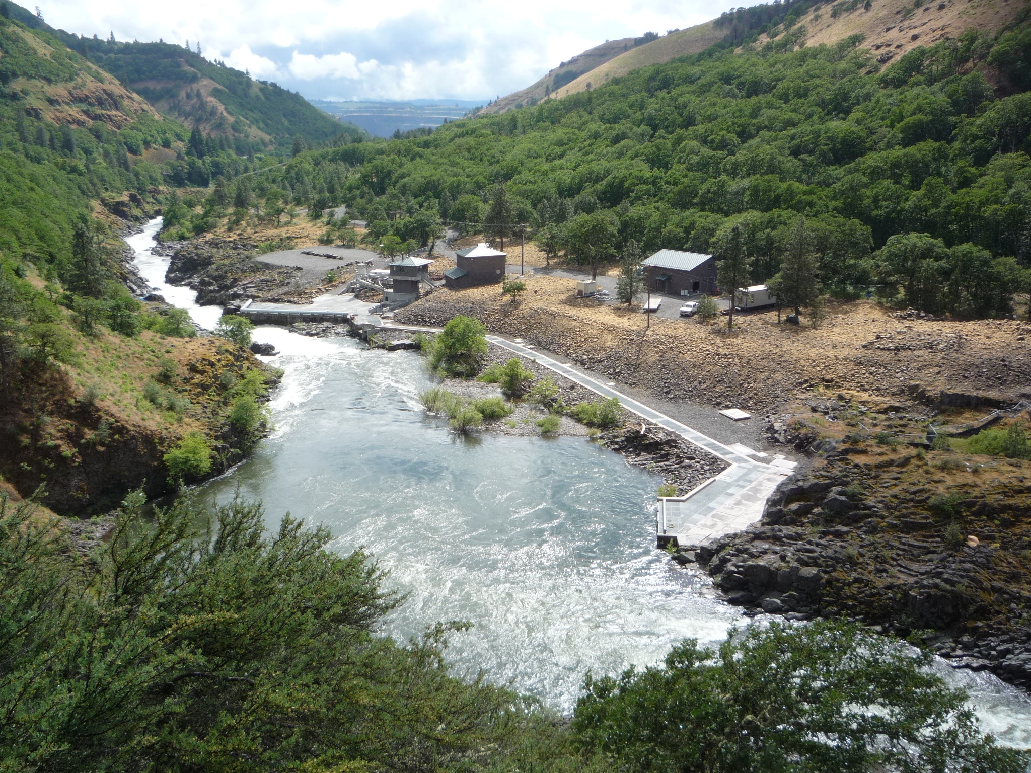
The Klickitat Field Office (KFO) is the regional fishery office for the Yakima/Klickitat Fisheries Project in the Klickitat subbasin and Southern Ceded Area.
The KFO is located in Wahkiacus, WA at RM 17 of the Klickitat River, near the confluence of Swale Creek.
Staff at the KFO includes Fishery Biologists, Habitat Biologists, Data Manager, Watershed Planner, and habitat and fisheries technicians.
Meet the staff. (Coming soon.)
Physical address: 1575 Horseshoe Bend Rd., Klickitat, WA 98628
Wahkiacus Hatchery Acclimation Facility (WHAF)
As identified in the Draft Klickitat Anadromous Fishery Master Plan (KMP), transferring U.S. v. Oregon production stocks (coho and fall Chinook) to the WHAF accomplishes two primary objectives:
- it frees up critical water and space at the Klickitat Hatchery, ensuring that optimal rearing densities and protocols (YKFP and Hatchery Scientific Review Group [HSRG] guidelines) are met for the two endemic stocks (Klickitat spring Chinook and Klickitat summer steelhead)
- transferring coho and fall Chinook production 26 miles downriver minimizes the impacts of large-scale hatchery releases on wild spring Chinook and steelhead rearing between the two facilities.
The 26 miles of river between Klickitat Hatchery (RM 42.6) and WHAF (RM 17) lies within the 3 EDT reaches (Lower Klickitat, Middle Klickitat and Upper Middle Klickitat). EDT model output generated from physical habitat surveys identify these reaches as having the highest potential for restoration and preservation in the subbasin. Annual steelhead spawner surveys indicate that 60% of the mainstem spawning occurs in these reaches.
Additionally, release of well-acclimated coho and fall Chinook from WHAF imprinted to the local groundwater signature will concentrate returns to the immediate proximity of the facility, where concentrated harvest can occur, as natural production of coho and fall Chinook is not a program objective.